Double HIGH RISK issued by the NWS
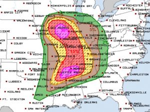
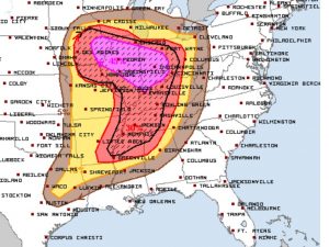
A HIGH RISK has been issued by the Storm Prediction Center for Violent, Long Tracked Tornadoes and Severe Wind and Hail. It is extremely important to stay weather aware and listen to all warnings. This will be impacting Eastern Iowa and Central Illinois all the way south into Tennessee and Mississippi.
Be sure to tune into Severe Studios on YouTube to watch LIVE storm coverage and chasers today during the event. Follow us on Twitter for up to date coverage.
What People Are Saying...
Twitter Mentions
Reddit
Jetpack Comments